Backpacking in Sequoia National Park - Day 3 (Bearpaw Meadow to Hamilton Lakes and Back)
Our first morning in Bearpaw Meadow, I woke up with the sun again. The other guys were still sleeping, so I took advantage of the situation to get some alone time with God. I grabbed my Bible and journal and hiked up to the High Sierra Camp where I had seen a picnic table the previous evening. The view of the Sierras from there is simply breathtaking. There is just something about spending time with God when you're out in nature that is so uplifting.

After my quiet time, I headed back down to our campsite where the other guys were stirring. This morning was much easier to get ready because we didn't have to tear down our tents and could pack our bags lighter. In fact, I actually had to put some extra stuff in mine just to get it to fit right (my pack is 65 liter). Nate was the smart one who actually brought a separate, smaller pack for the day hikes. After breakfast and coffee, we filled up our hydration bladders and got ready to set out. One side note (hope it isn't TMI), that morning marked the first time I had ever pooped in a hole in the ground. The campground had a couple of pit toilets, but they were too gross and bug infested for me to want to spend any time in them. So I opted for digging and burying on my own. I was strangely proud of myself for this accomplishment. Once all that business was taken care of, we began the day's trek. The other guys hadn't seen the view from the High Sierra Camp yet, so on our way out, we stopped there to have a look.


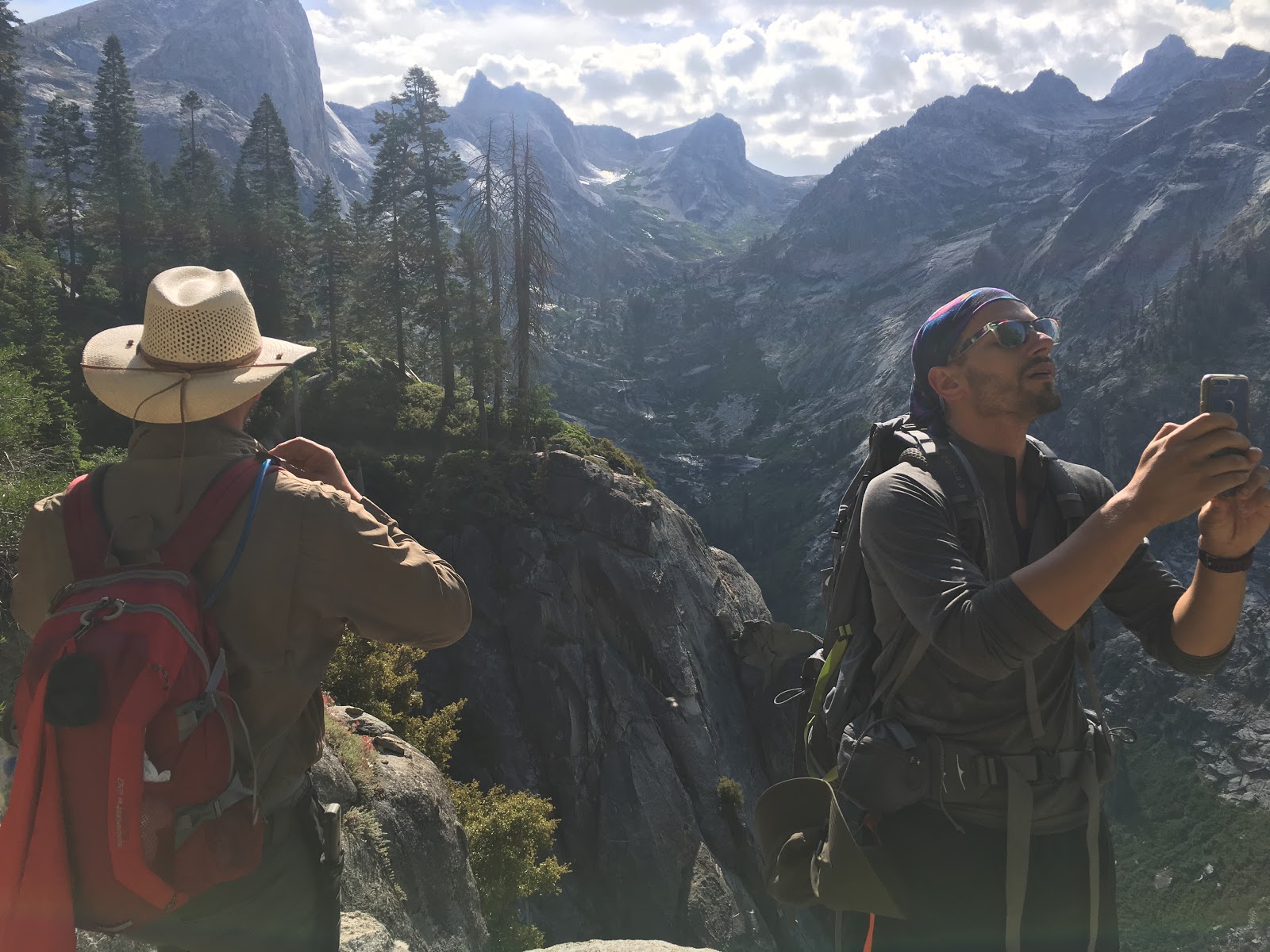
My favorite spot we passed through that morning was where there was a sharp turn in the trail that went right along a cliff. There was this cool, smooth rock wall to one side, and then, when the trail turned back to the north, there was this sweet ledge that stuck out into the ravine below.


As we continued down along the ridge we could see across the way where Hamilton Creek came down from the mountains and joined with Lone Pine Creek below. We knew that our hike that day would eventually lead us up Hamilton Creek to Hamilton Lakes, but we didn't quite know how at this point. The canyon carved out by Hamilton Creek was quite beautiful though.


Looking down off the bridge, you could see some of the structure of the previous bridge still lying in the rocky canyon below. I thought it was interesting that they never removed it. However, I suppose that would be a ton of work, seeing as we were over 13 miles from the nearest road. Once we crossed the bridge, the hard part began: climbing.

After following the edge of creek a bit, the trail turned east and began switchbacking up the front side of the peak in front of us. We weren't yet entering the Hamilton Creek river canyon.
As we approached the "corner" if you will, where we would cross into the Hamilton Creek canyon, we were not without incredible vistas. Sometimes it was hard to keep hiking because you just wanted to stare at your surroundings, pinching yourself to make sure it was real.


The "corner" I was speaking of actually happened to mark approximately half way up to Upper Hamilton Lake, so we were making progress towards our destination.
As we turned the corner, we got a short reprieve from climbing as we actually descended into the north side of the canyon. It was a welcome change of pace, and seeing more of the creek was getting us excited for what awaited us as we continued our trek.


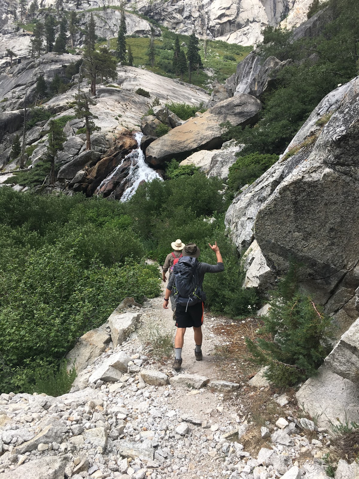
As we drew nearer to Hamilton Creek, we began to see that the trail was going to take us right to where there was a double waterfall cascading down a giant slab of rock (you can see it in the distance in the above photo, and a little closer below).

The trail forded the creek just above the falls where the water was very shallow as it ran along the face of the rock.

I can sometimes get vertigo if I get too close to the edge of a high place, so I stayed away from the edge of the falls. The other guys do not share my condition, however, and they got nice and close.

Right behind the double falls was another beautiful waterfall that broke over a lot more rocks as it crashed down.

Once we forded the creek, we started climbing up along the south side of it. From here we got a great look at these towering cliffs of stone that made up the north side of the canyon. They were so high, and unfortunately, the photos just don't capture the grandeur of them.

Not too much farther and we came to Lower Hamilton Lake. We knew that meant that our destination for the day was just up the trail a bit. Next to lake was a beautiful alpine meadow and, of course, those cliffs on the north side of the creek were still well in view.

Just a little further up the trail, we reached our destination for the day: Upper Hamilton Lake. The lake was fairly large and sat in a bowl of rock, surrounded on three sides by rocky peaks. The "shore" if you will, was also solid rock and gave a great place to sit, chill, and just soak in the beauty of this place.
I had brought my swimsuit with me on the backpacking trip, but forgot to pack it in my pack for the day hike. Doh! So I didn't go for a swim like I had intended. Alex got in and enjoyed the water though, and Nate and I sat on the rocky shore and soaked our sore feet in the cool water.


On our way to the shore, we saw John whom we had met at lunch at the Visitor's Center after we got our permits. He was heading onward and upward, but had stayed at the High Sierra Camp the night before "glamping." After a hearty prepared dinner and breakfast, he was ready to keep making his way to Mt. Whitney. Shortly after we got settled in, we saw more and more backpackers arriving at the lake. We saw Avi and Jordan, our Bearpaw neighbors from the night before. We also saw the couple who stayed at Buck Creek the night before, and a group of three backpackers with whom we kept playing leap frog on the first day. We asked them to snap a picture of all three of us by the lake.

After we chilled there for a couple hours (even felt a few sprinkles from the clouds overhead), recharged with some food, and refilled our bladders from the lake, it was time for us to head out. It was actually kind of sad to say goodbye to the other backpackers we had met and with whom we kept crossing paths. Since we were turning back, we knew that we wouldn't see them anymore. Again, the camaraderie amongst the backpackers was a really cool element of this trip that I wasn't expecting, but really enjoyed.

As we started back down from the lakes, we had decided to take a slightly different route back. We would descend the High Sierra Trail down to Lone Pine Creek, but then take the Tamarack Lake Trail up the creek to the Over the Hill Trail that would take us back to Bearpaw a slightly different way. All in all, it would add almost two miles to our return trip.


We took a quick breather when we reached the trail that headed north toward Tamarack Lake. We knew that we were adding a little bit of elevation to our trip today, but I don't think we realized how much climbing would be involved. However, it was totally worth the extra work.
As the trail began, it was very overgrown! You could tell that not many people took this trail. Most people headed to Tamarack Lake probably take the Over the Hill Trail from Bearpaw and don't take the part of the trail that runs along the east side of Lone Pine Creek. We managed to not lose the trail thankfully!
Once we got through the overgrown part of the trail, it started climbing pretty steeply up to the top of some falls that we had seen further down, but were unfortunately not visible from higher up. Even without the falls in view, however, the higher elevation was already giving us some vistas and perspectives that we had not seen before.

There was this cool half pipe formation on the the west side of Lone Pine Creek that was really cool.


Once we got to the top of the climbing part of the Tamarack Lake Trail, we found this sweet rock formation that the guys thought would be perfect for epic pictures. They were absolutely right.

Unfortunately, when getting down from the epic rock formation, Alex hurt his achilles. Thankfully, Nate was a nurse, so he was able to wrap it up nicely and take some of the pressure off.
Soon after Alex's foot was all wrapped up, we came to the spot where we had to ford Lone Pine Creek. No handy dandy bridge to cross up here.

As we climbed up the hill, we got some great new perspectives on the range to the east of Lone Pine Creek. We got a great view of some of the trails on which we had hiked earlier in the day. It was awesome to look back and see how far we'd come.
There were again, so many wildflowers and rich vegetation along the trail as it climbed up toward the forest.

While on this trail, we also met the local Ranger for the Bearpaw Meadow area. Her name was Alicia and she was very nice. Since we were completely off the grid and Nate and I both have wives and kids at home, we were glad to run into the ranger. We figured if by some crazy happenstance something urgent was happening back home, our wives could reach the ranger and she would know who we were and how to find us. There was also the wildfire happening on the other side of the High Sierra Trail that we though could have had people back home worried if they'd heard about it, even though it was no where near where we were. There was one more clearing we reached before finally going over the hill, and I decided to pose on top of a boulder there.


The last part of the Over the Hill trail was heavily wooded and actually a pretty steep descent as it led us back to the Bearpaw Meadow Campground. When we reached our camp, we made our dinners and then headed up to the High Sierra Camp to stare at the view and enjoy some libations.

The High Sierra Camp sells beer and wine (I know, glamping hardcore). Nate didn't have any because he didn't want to be dehydrated, but Alex and I thought it would be worth the risk. Plus, the beverages were surprisingly inexpensive given the remote circumstances. The box I had was only $10 and it was the equivalent of three glasses of wine!
Once the sun dipped low enough in the sky that it wasn't lighting up the Sierras to the east, we headed back down to our campsite and actually built a fire. It was the perfect way to close out what was probably my favorite day of our adventure. There was just so much mind-blowing beauty, and then to top it all off with good friends, wine, and a campfire--it doesn't get much better than that!


After my quiet time, I headed back down to our campsite where the other guys were stirring. This morning was much easier to get ready because we didn't have to tear down our tents and could pack our bags lighter. In fact, I actually had to put some extra stuff in mine just to get it to fit right (my pack is 65 liter). Nate was the smart one who actually brought a separate, smaller pack for the day hikes. After breakfast and coffee, we filled up our hydration bladders and got ready to set out. One side note (hope it isn't TMI), that morning marked the first time I had ever pooped in a hole in the ground. The campground had a couple of pit toilets, but they were too gross and bug infested for me to want to spend any time in them. So I opted for digging and burying on my own. I was strangely proud of myself for this accomplishment. Once all that business was taken care of, we began the day's trek. The other guys hadn't seen the view from the High Sierra Camp yet, so on our way out, we stopped there to have a look.


From the Bearpaw High Sierra Camp, the trail began by descending down the ridge on the west side of Lone Pine Creek. The path cut through a ton of lush undergrowth, beautiful wildflowers, and several trickling streams. It was so green and beautiful, and the view across the creek of the mountains was truly awe-inspiring.


My favorite spot we passed through that morning was where there was a sharp turn in the trail that went right along a cliff. There was this cool, smooth rock wall to one side, and then, when the trail turned back to the north, there was this sweet ledge that stuck out into the ravine below.


Finally, we saw how we were getting across Lone Pine Creek: a bridge! We were relieved that we didn't have to hike all the way down to the level of the creek before crossing. After all, the more you descend, the more you'll have to ascend later on.

The High Sierra Trail was created in the 1920's, and it seems as though the original bridge that crossed Lone Pine Creek had some issues.


After following the edge of creek a bit, the trail turned east and began switchbacking up the front side of the peak in front of us. We weren't yet entering the Hamilton Creek river canyon.
As we approached the "corner" if you will, where we would cross into the Hamilton Creek canyon, we were not without incredible vistas. Sometimes it was hard to keep hiking because you just wanted to stare at your surroundings, pinching yourself to make sure it was real.


The "corner" I was speaking of actually happened to mark approximately half way up to Upper Hamilton Lake, so we were making progress towards our destination.
As we turned the corner, we got a short reprieve from climbing as we actually descended into the north side of the canyon. It was a welcome change of pace, and seeing more of the creek was getting us excited for what awaited us as we continued our trek.


As we drew nearer to Hamilton Creek, we began to see that the trail was going to take us right to where there was a double waterfall cascading down a giant slab of rock (you can see it in the distance in the above photo, and a little closer below).

The trail forded the creek just above the falls where the water was very shallow as it ran along the face of the rock.

I can sometimes get vertigo if I get too close to the edge of a high place, so I stayed away from the edge of the falls. The other guys do not share my condition, however, and they got nice and close.

Right behind the double falls was another beautiful waterfall that broke over a lot more rocks as it crashed down.

Once we forded the creek, we started climbing up along the south side of it. From here we got a great look at these towering cliffs of stone that made up the north side of the canyon. They were so high, and unfortunately, the photos just don't capture the grandeur of them.

Not too much farther and we came to Lower Hamilton Lake. We knew that meant that our destination for the day was just up the trail a bit. Next to lake was a beautiful alpine meadow and, of course, those cliffs on the north side of the creek were still well in view.

Just a little further up the trail, we reached our destination for the day: Upper Hamilton Lake. The lake was fairly large and sat in a bowl of rock, surrounded on three sides by rocky peaks. The "shore" if you will, was also solid rock and gave a great place to sit, chill, and just soak in the beauty of this place.
I had brought my swimsuit with me on the backpacking trip, but forgot to pack it in my pack for the day hike. Doh! So I didn't go for a swim like I had intended. Alex got in and enjoyed the water though, and Nate and I sat on the rocky shore and soaked our sore feet in the cool water.


On our way to the shore, we saw John whom we had met at lunch at the Visitor's Center after we got our permits. He was heading onward and upward, but had stayed at the High Sierra Camp the night before "glamping." After a hearty prepared dinner and breakfast, he was ready to keep making his way to Mt. Whitney. Shortly after we got settled in, we saw more and more backpackers arriving at the lake. We saw Avi and Jordan, our Bearpaw neighbors from the night before. We also saw the couple who stayed at Buck Creek the night before, and a group of three backpackers with whom we kept playing leap frog on the first day. We asked them to snap a picture of all three of us by the lake.

After we chilled there for a couple hours (even felt a few sprinkles from the clouds overhead), recharged with some food, and refilled our bladders from the lake, it was time for us to head out. It was actually kind of sad to say goodbye to the other backpackers we had met and with whom we kept crossing paths. Since we were turning back, we knew that we wouldn't see them anymore. Again, the camaraderie amongst the backpackers was a really cool element of this trip that I wasn't expecting, but really enjoyed.

As we started back down from the lakes, we had decided to take a slightly different route back. We would descend the High Sierra Trail down to Lone Pine Creek, but then take the Tamarack Lake Trail up the creek to the Over the Hill Trail that would take us back to Bearpaw a slightly different way. All in all, it would add almost two miles to our return trip.


We took a quick breather when we reached the trail that headed north toward Tamarack Lake. We knew that we were adding a little bit of elevation to our trip today, but I don't think we realized how much climbing would be involved. However, it was totally worth the extra work.
As the trail began, it was very overgrown! You could tell that not many people took this trail. Most people headed to Tamarack Lake probably take the Over the Hill Trail from Bearpaw and don't take the part of the trail that runs along the east side of Lone Pine Creek. We managed to not lose the trail thankfully!
Once we got through the overgrown part of the trail, it started climbing pretty steeply up to the top of some falls that we had seen further down, but were unfortunately not visible from higher up. Even without the falls in view, however, the higher elevation was already giving us some vistas and perspectives that we had not seen before.

There was this cool half pipe formation on the the west side of Lone Pine Creek that was really cool.


Once we got to the top of the climbing part of the Tamarack Lake Trail, we found this sweet rock formation that the guys thought would be perfect for epic pictures. They were absolutely right.

Soon after Alex's foot was all wrapped up, we came to the spot where we had to ford Lone Pine Creek. No handy dandy bridge to cross up here.

Across the creek we found the trail junction for the Over the Hill Trail, named appropriately as it literally goes up and over the hill to Bearpaw Meadow from this location.
As we climbed up the hill, we got some great new perspectives on the range to the east of Lone Pine Creek. We got a great view of some of the trails on which we had hiked earlier in the day. It was awesome to look back and see how far we'd come.
There were again, so many wildflowers and rich vegetation along the trail as it climbed up toward the forest.

Once we reached the forest, we were relieved to be in the shade, but missed the sweeping vistas. However, when we reached a clearing, we noticed we could see the bowl that Upper Hamilton Lake sits in.
While on this trail, we also met the local Ranger for the Bearpaw Meadow area. Her name was Alicia and she was very nice. Since we were completely off the grid and Nate and I both have wives and kids at home, we were glad to run into the ranger. We figured if by some crazy happenstance something urgent was happening back home, our wives could reach the ranger and she would know who we were and how to find us. There was also the wildfire happening on the other side of the High Sierra Trail that we though could have had people back home worried if they'd heard about it, even though it was no where near where we were. There was one more clearing we reached before finally going over the hill, and I decided to pose on top of a boulder there.


The last part of the Over the Hill trail was heavily wooded and actually a pretty steep descent as it led us back to the Bearpaw Meadow Campground. When we reached our camp, we made our dinners and then headed up to the High Sierra Camp to stare at the view and enjoy some libations.

The High Sierra Camp sells beer and wine (I know, glamping hardcore). Nate didn't have any because he didn't want to be dehydrated, but Alex and I thought it would be worth the risk. Plus, the beverages were surprisingly inexpensive given the remote circumstances. The box I had was only $10 and it was the equivalent of three glasses of wine!
Once the sun dipped low enough in the sky that it wasn't lighting up the Sierras to the east, we headed back down to our campsite and actually built a fire. It was the perfect way to close out what was probably my favorite day of our adventure. There was just so much mind-blowing beauty, and then to top it all off with good friends, wine, and a campfire--it doesn't get much better than that!


As always, one of the best thing you can do to} do} is to keep checking back 코인카지노 with Spin Casino and see if they’ve made any adjustments. You can all the time contact their live chat service to examine with them on particular video games or any upcoming policy adjustments. They might finally set a specific restrict usually, or it could remain variable relying on the video games you choose to play.
ReplyDelete